Professionals & Teams
Built for the field. Trusted by teams.
The backcountry navigation app for SAR, fire, forestry, survey, and utility teams — with custom data layers, US public and private land, and team subscriptions that don’t take months to set up.

Built for the field
Real navigation. With the data tools on top.
A lot of professional mapping tools are built for the office — heavy enterprise GIS suites that can do anything in a desk chair but slow down, lock up, or charge another seat the moment they hit a phone in the field. Topo Maps+ is the other way around. Built for real backcountry navigation first — the same offline-anywhere map serious hikers and field pros rely on — then layered with the data tools field teams need: custom data layers with your own attributes and styles, US public and private land, hunting units, custom map imports, and coordinate grids.
“I’m a wilderness worker — work in extremely remote out-of-the-way places. This app is ALWAYS dead-on accurate. Take it from a pro, great app.”— Tetonsareus, App Store review

Across disciplines
Same map. Different jobs.
Search & Rescue
Track who’s covered which ground, share a common location to keep the team on the same page, and build a Plan B route when the first one doesn’t pan out. Drop Distance Rings — custom-radius search rings around a last-known point or planning waypoint — to define and divide coverage. Print paper maps for the briefing or for crew who’d rather have one in a pocket.
Wildland Fire
Mark divisions, drop points, helispots, water sources, and structure protection using standard ICS and NWCG symbology — and build custom data layers for everything else. Send a common location to the whole strike team in one tap, on the line where Google Maps gives up. The map keeps working without cell service all day, and every crew member with the app sees the same picture.
Forestry & Land Management
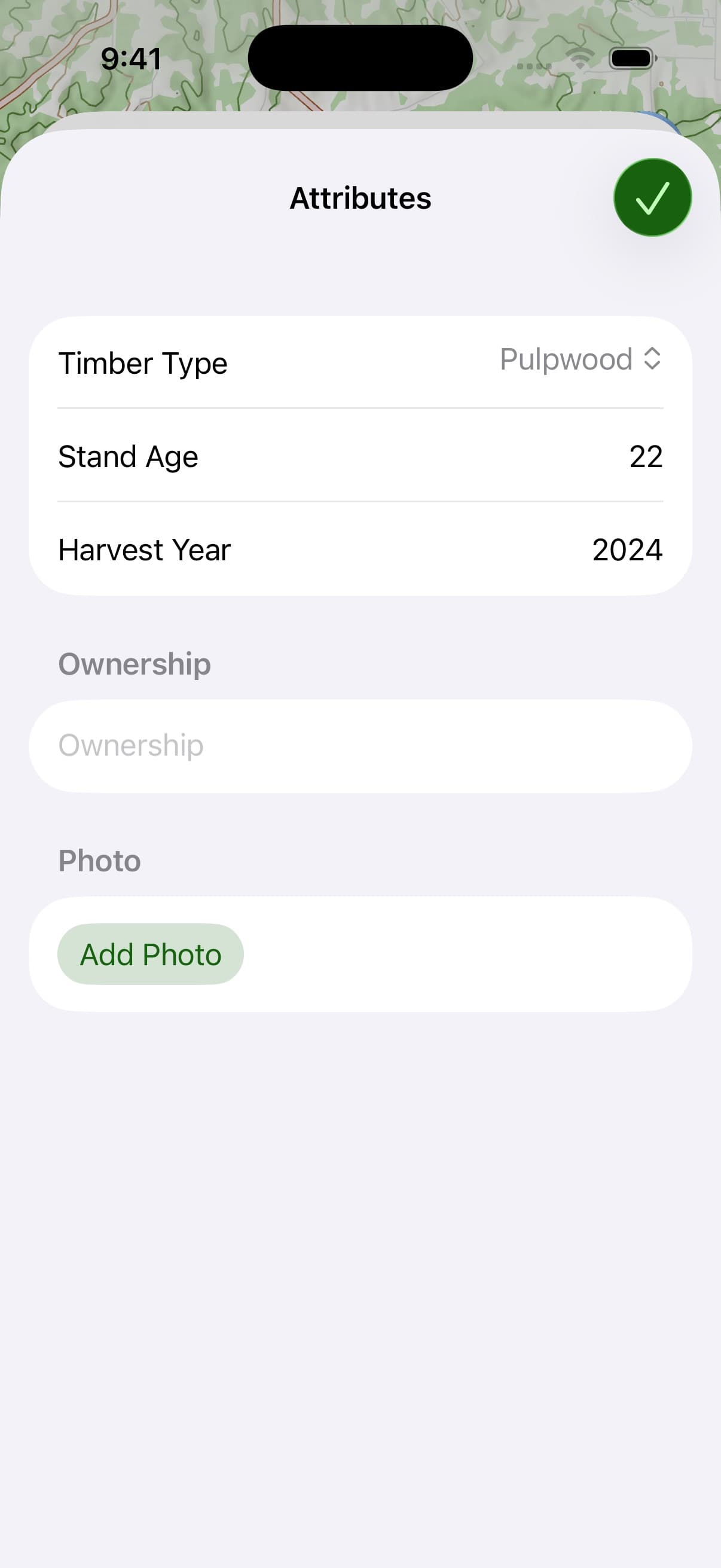
Mark survey points, harvest units, treatment areas, and access roads with custom attributes that match your data — timber type, stand age, harvest year, ownership, whatever you need to record. Sync across the crew’s devices through the Topo Maps+ account. Import a GeoPDF of a project map and navigate on it like any other layer.
Survey & Utility
Plot in UTM or lat/lon, build custom data layers with your own attributes and styles, navigate to field locations with downloaded offline maps, and export GPX to inReach, Garmin, or whatever else you carry. Works past pavement, past cell service, past the cloud.
Map data, boundary data, and access information can change. Verify with the appropriate authority before you go.
A cheaper, easier alternative to ArcGIS Field Maps.
If you’ve used ArcGIS Field Maps in the field, you know the friction — slow on a phone, expensive per seat, locked into one ecosystem, and a procurement cycle to grow. Custom Data Layers (Elite) give field teams a different option: build your own data overlays with your own attributes and styles, sync them across your team through a Topo Maps+ account, and use them on the same map you already use for navigation. Faster to set up. Easier to use day-to-day. A fraction of the cost. And no enterprise contract to subscribe a team.
Teams
Free to create. Easy to subscribe.
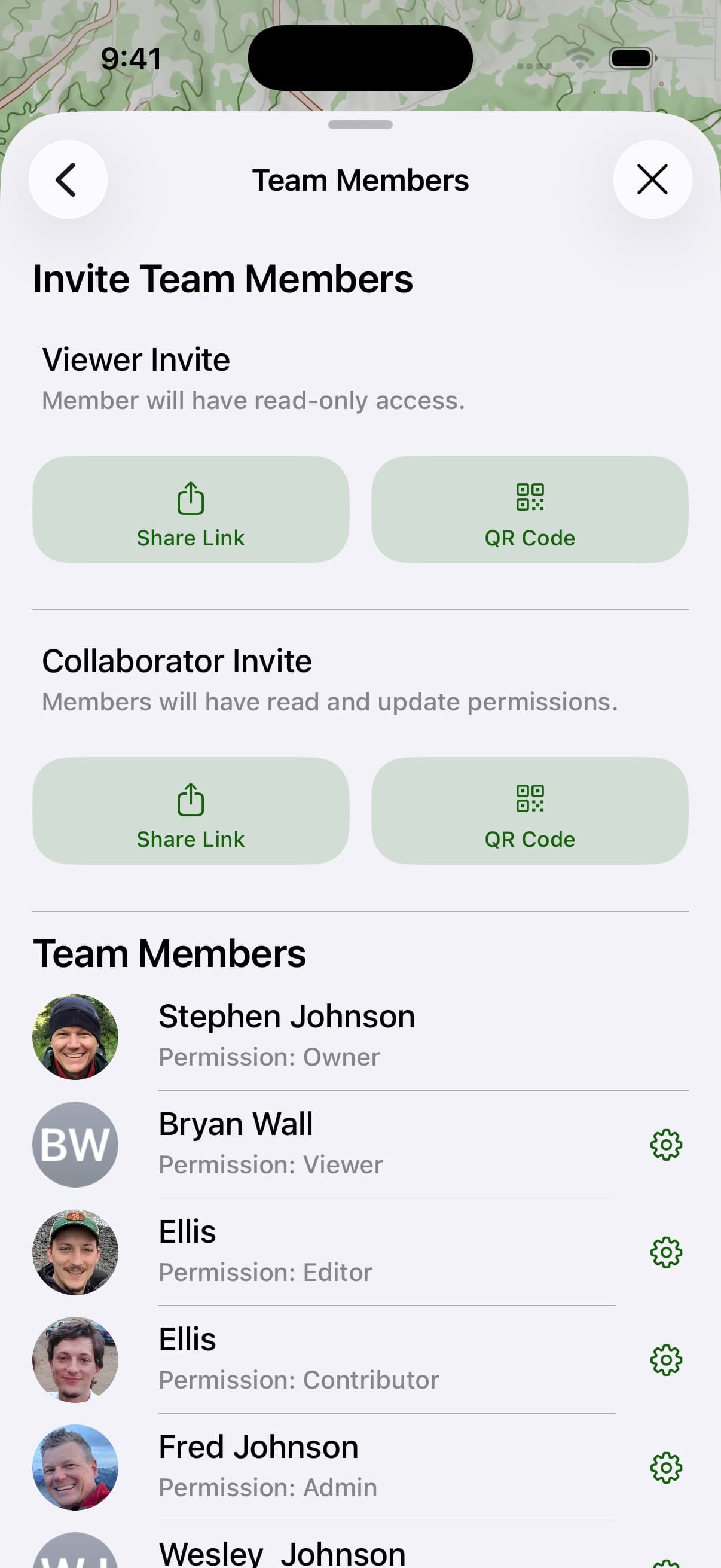
Topo Maps+ teams are free to create — bring in your crew, share routes, waypoints, and data layers, and start working together right away. When you’re ready to subscribe the whole team to Pro or Elite, get in touch and we’ll sort out the right plan for your size and use case. Most team conversations happen over a single email, not a quarter of procurement.
From the field
What pros actually do with it.
“I’m the search and recovery deputy for a county close to the Texas/Mexico border. Using this app allows me to see where I have been so I can better plan my searches. I would not be as effective without this app.”
“As a member of a K-9 SAR department this app is excellent for searches and for marking covered areas.”
“Being part of an organized search-and-rescue association, it’s really important to know where you are, where you are going, and being able to develop a Plan B. This app does that and so much more.”

Start in the field
Try it. Build the team. Talk to us when you’re ready.
Free to try in your browser. The 7-day free trial unlocks Elite for individual use. Teams are free to create, and team subscriptions go through sales.